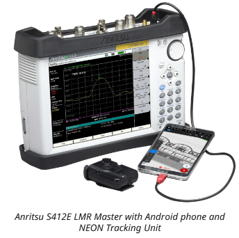
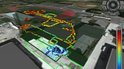
The National Fire Protection Association adopted public safety radio indoor coverage requirements several years ago that are used for ensuring that first responders have adequate indoor coverage. Many stakeholders, from building owners to cities and their first responders, need to know that coverage requirements are being met and have insight into coverage measurements throughout a building or venue.
Ultimately, stakeholders want to know if a communications system will hold up when it is most needed. Getting that information requires careful and accurate assessment of radio frequency coverage, including positioning information. But Global Positioning System (GPS) signals are often unavailable or unreliable indoors, making it difficult to conduct accurate signal mapping. In addition, most indoor mapping tools offer only a two-dimensional mapping that may not capture the complexity of environments such as elevators and stairways – but these are locations where it’s particularly important for first responders to have good coverage. Anritsu solves this issue of RF blind spots with a three-dimensional, real-time approach to signal mapping that was originally developed to keep tabs on firefighters moving around inside buildings.
“This technology came about from personnel tracking, and then we saw a good fit for this technology for coverage mapping,” said Wayne Wong, product manager with Anritsu. “This is a very unique product. There isn’t another product that does the automatic 3D tracking of a person while they’re doing RF measurements.”
Anritsu collaborated with TRX Systems to leverage its NEON indoor location tracking and mapping solution and develop the MA8100A series TRX NEON Signal Mapper. A tracker and TRX software, used in conjunction with Anritsu’s LMR Master handheld instrument, enable lightly-trained users to be able to quickly and accurately map signal and sensor information inside buildings. The NEON system can be used with any of Anritsu’s handheld instruments which include spectrum analyzers, but supports some additional testing features when used with the LMR Master that include bit-error rate, modulation fidelity/EVM and RSSI, Wong said.
Most indoor mapping tools require the user to manually track their position by tapping a tablet, Wong added, and those points can either be incomplete and may have extrapolated data that doesn’t accurately reflect the radio environment. Other set-ups also often rely primarily on end-user devices rather than measurement-grade instruments that are fully calibrated for consistent result reporting.
Data visualization is also a key component, he noted, with the accompanying software able to quickly generate 3D coverage maps, breadcrumbs or play the test walk as a 3D video. Cloud capabilities enable test results to be rapidly transmitted back to supervisors who can review the data and check for gaps in coverage or additional data points that are needed to avoid the costs associated with multiple visits.

