The FAA and industry are working together on UAV regulatory issues: it may take years to work out a viable UAV traffic management system.
Without a doubt, the U.S. Federal Aviation Administration’s Part 107 rule has made a big difference in making drone-based tower inspections less bureaucratic for U.S. industry.
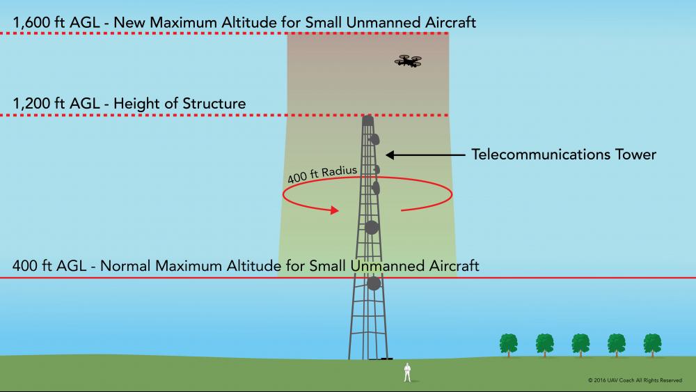
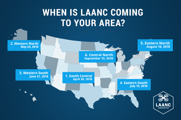
Under the FAA’s Part 107, drone pilots can become certified to fly and don’t need a full-blown aircraft pilot’s license. Part 107 holds a drone flight down to under 400 feet, or, if flying around a tower, 400 feet around the tower itself, including above the tower. Also, pilots can’t fly near certain areas, such as an airport; or over people. The drone must also always be within its pilot’s line of sight. Anything outside of the Part 107 rules requires filing a waiver/flight plan with the FAA. There are now near-real-time services under the Low Altitude Authorization and Notification Capability (LAANC) to help streamline that filing through some drone service providers.
[Don’t miss special report and webinar “Operators taking flight: The emerging role of drones in network operations and maintenance”]
“When Part 107 took effect, it broadly enabled commercial operations of drones for many industries, however certain restrictions still exist under this new rule,” explained Gretchen West, a senior advisor in Silicon Valley, for the Commercial Drone Alliance and law firm Hogan Lovells US. West is a member of the firm’s Global Unmanned Aircraft Systems (UAS) Group in Silicon Valley. “For tower inspectors, their ability to operate under Part 107 has been useful as they’re able to operate at higher altitudes to inspect tall towers as long as they maintain a close perimeter to the structure or tower,” she said.

The restrictions on operating over people or flying a drone at night, although not issues for tower inspectors, are challenges that they would still need to consider when flying drones commercially, said West. “Additionally, operators would need to fully understand the different laws and rules in various states and local jurisdictions in case any additional restrictions apply around privacy concerns or public nuisance,” she added. “Understanding all the rules of the air for tower inspectors is critically important to maintain safe operations; however, the tower industry is one that can certainly reap the vast benefits of drone technology.”

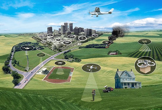
The next steps are getting beyond line of sight, night flying and flying over people, but those regulations are taking an effort among federal, state, local and industry stakeholders. NASA and the FAA are working on the Unmanned Aircraft System (UAS) Traffic Management (UTM), which will function like the current U.S. air traffic control system, only for drones and other low-flying aircraft. The system is years off but in development now. The key to making the system work will be good ground rules but also technology, as the number of UAVs in the air at one time will be impossible to manage without automation and artificial intelligence. The federal agencies have engaged industry to come up with projects that can help inform how the rules are written that help. The Unmanned Aircraft System (UAS) Integration Pilot Program (IPP), a three-year project, is part of those efforts.
“It’s all related: UTM, remote ID and these integrated pilot projects are all related in determining basically what technologies are viable and safe, and basically the best solutions for tracking drones — so that the government agencies will know that when they see or detect a drone, they will know if it is a safe actor or if it is a drone that is doing something malicious, so then they can take appropriate action.” said Art Pregler, who heads up AT&T’s drone program. “Also, that the drones themselves can ensure safe separation and that they are not going to collide with structures or other drones. The purpose is to serve all stakeholders.”
Whether the telecom carriers, government agency or some other entity ends up running the UTM, “we want the best solution for the flying public and the people underneath that flying public,” said Pregler. “If it is LTE that is the solution, which we believe that it is a very robust and capable solution for remote ID and UTM, then that’s great. If it is a combination of LTE and some other technology, that is great as well. It is what makes sense for the main stakeholders.”

The UTM now is in UTM Technology Capability Level 3, scheduled for Spring 2018. UTM TCL2 focused on testing technologies that maintain safe spacing between cooperative (responsive) and non-cooperative (non-responsive) UAS over moderately populated areas. UTM TCL4 tests over urban areas, for tasks such as news gathering and package delivery.
“We’ve been a big proponent on the regulatory side,” said PrecisionHawk’s Pat Lohman, speaking about the UTM. PrecisionHawk is an end-to-end drone service company with backing from Verizon Ventures; Lohman is the company’s VP of energy. “We partnered with the FAA over the past couple of years on specific projects around flying beyond line of sight. We’re very much involved on the privacy side on the pretty much anything that’s going to affect the industry from a regulatory or social aspect, because at the end of the day, we are incented to. We want to see this industry get even more legs over time. If there are blockers on the regulatory side or things that the industry can’t work through, then it is going to be a big hindrance as to how big the industry is in total.”
The FAA and industry are also collaborating on LAANC, a system through which UAS pilots apply for airspace authorizations. LAANC automates the application and approval process for airspace authorizations for controlled airspaces, such as flying near an airport, even when under 400 feet. Through an automated applications process developed by FAA-approved UAS Service Suppliers (USS), pilots apply for an airspace authorization online. The wait time is decreased to real-time approvals in some cases, and pilots have greater flexibility in operational planning.
The FAA approved these companies to provide LAANC services:
- AirMap
- Project Wing
- Rockwell Collins
- Skyward

